Mount Tujanit, Albania
At 1583m, Mount Tujanit - Maja e Tujanit in Albanian - rises dramatically out of the landscape surrounding Albania’s capital city, Tirana. Visible for miles in any direction, this beast of a peak has snow on it’s summit for 7 months of the year. Dominating the skyline of Tirana along with it’s twin Mount Dajti, Tujanit just begs to be scaled. We were informed that Mount Dajti itself is currently closed to hikers due to being used by the Government for military exercises.
Mount Tujanit is part of the Skanderbeg range and is a rocky formation protected by the Dajti Mountain National Park. During the winter months this mountain and others nearby are popular for skiing, but you won’t be able to reach the summit unless the snow has melted completely. We visited in April 2023 and there were a few small patches of ice near to the summit but nothing to stop an easy hike without ice-grips or extra gear.
Climbing to the summit of Mount Tujanit is something anyone visiting Tirana should add to their list - it’s more than just a hike with a great view. Going up Tujanit includes going to a different area of the city, a cable car, an activity park including Albania’s first 18 hole mini golf course, and it even has an on site bar and restaurant for those that get peckish half way up.
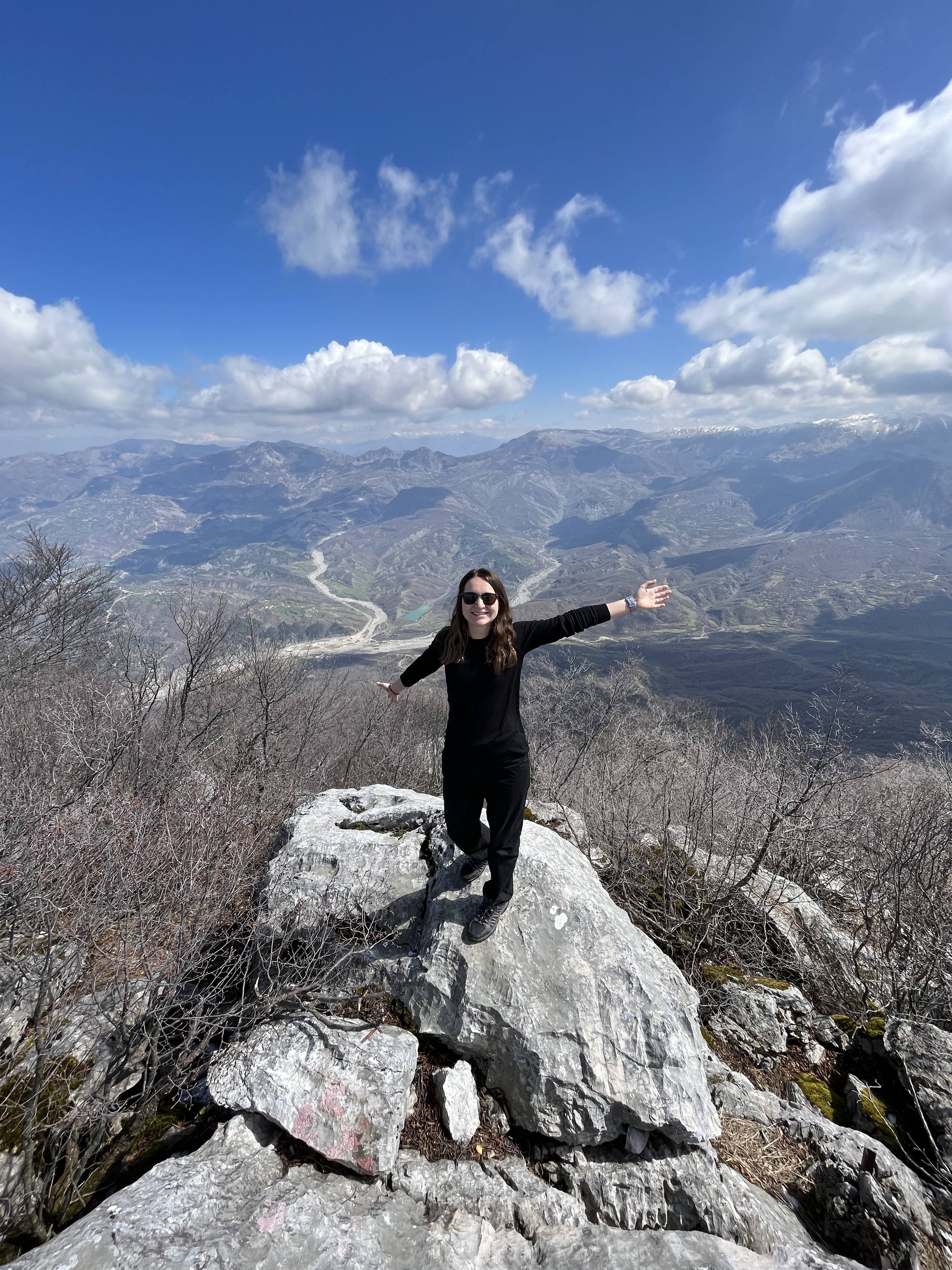
At the summit of Tujanit
Start/end point: Dajti Express station
Average duration: 2 hours
Distance: 6km out and back hike
When to go: April-September - Summer months are best for the hike to avoid snow and ice
Difficulty: Easy-Moderate
Maps/Info: Information for hiking in Albania is scarce and the best way to find out about trails and whether they are passable is to check with locals. There are staff at the top of the cable car you could ask for guidance if needed. You may find that tours operate in groups from Tirana if you research or ask at Tourist Information.

The cable car:
Park your car for free at the bottom station of the Dajti Express cable car, or get the bus from central Tirana. The station is only about 10-15 minutes out of the centre of the city, depending on that day’s level of traffic chaos! If you are getting the bus, get on the Qender - Porcelan one - it is blue and departs from the clock tower in the centre of the city near Skenderbeg square.
On their website, https://dajtiekspres.com/, it says the cable car opens at 9am most days (it is closed on Tuesdays!). We arrived at just gone 9am and the cable car didn’t start until 9.30am. I still advise you to get there early, as hiking in summer in Albania is much easier before the heat of the day sets in.
The 4670m long cable car is in itself an attraction which provides incredible views over Tirana, and if you don’t like hiking perhaps you can consider getting a return trip on the cable car and going for lunch or playing mini golf at the top instead. The ride to the top takes about 15 minutes and costs 1200lek per person for a return ticket (approx. 11 euros).
The hike:
Leaving the cable car upper station, head out towards the massive abandoned hotel in the grounds directly in front of you. It’s hard to miss, but ask staff if you can’t locate it.

Freaky abandoned hotel at the top of the Dajti Express cable car station
Spend some time looking around the abandoned hotel if you like - use torches, it’s very dark and creepy inside. You could literally play the best and most frightening game of hide and seek in there!
Once you’re done freaking yourself and your mates out, head around the back of the abandoned hotel and you’ll see dense woodland which goes steeply uphill. There are a few trail options here, and all of them take you upwards for the first kilometre. You can take any route up at this stage, but eventually want to end up on the trail with the red and white markers painted onto trees and rocks.

Red and white marker on a tree

Some markers are harder to spot - red and white marker on small rock
The trail can be easy to lose due to the markers being quite small or hard to spot in places so go slow and steady through this section of woodland - we took a left turn down a track which was wrong and we had to retrace our steps to find the trail again quite early on in the hike.
Keep climbing uphill through the woods which are a great shelter from the summer sun, and listen out to all the bird calls and rustling leaves which signal wildlife around you. You are now in the Dajti National Park and you will find that you don’t see many other people hiking here unless it’s mid-summer.
Keeping on a steady uphill incline you will cross a couple of dirt track roads. Ignore the tracks and go straight over, finding the markers for the trail again before continuing. A couple of kilometres into the climb you will come across a trail marker which says the walk is a further 1 hour 10 minutes (we would have liked to know the distance here as timings can be subjective based on fitness levels/age/ability etc.). In actual fact this next section took us only around 30-40 minutes.

Continuing on uphill for another kilometre or so, you may find your progress is slow but steady due to the incline. There are lots of wild flowers, plants and mushrooms growing wild in the woods here which you may find interesting as you walk.

Wildflowers in Dajti National Park
Just as you think you can’t walk much further through woodland, you will come to a clearing where there is another way-marker. This clearing is a great spot to sit down and rest, have a picnic or some water. The signpost for the trails which is located here is broken and the Mount Tujanit post is no longer there; you will see the information for Dajti which is 45 minutes further with a trail off to the right. The trail that you need to take here is LEFT towards Tujanit.

Broken signpost and information board at the clearing
From this point on you are exposed to the elements - and you will find that when you emerge from the woods the temperature is actually quite a lot cooler as you have climbed a good two hundred metres. Regardless of the temperature, if the sun is out you are going to feel it!
The last section of the trail is a meandering gravel track which is short but steep and zigzags back on itself a few times to enable you to summit the mountain fairly quickly. The views from this point on are over the city of Tirana and there are some great spots to sit and admire them.
Continuing on for another 5-10 minutes you will reach the summit of Maja e Tujanit where the panoramic views over the surrounding mountain ranges, valleys and lakes will blow you away.

Summit of Tujanit, 1583m
TOP TIPS:
Summer in Albania can reach 35-40 degrees Celsius, so take plenty of water and snacks for this hike.
Go up on the first gondola ride of the day to get started with the hike early and avoid the hottest part of the day.
Take some cash up with you in case you need food/drink at the cable car station - Albania is a country which for the most part only accepts cash.
Don’t expect to see lots of other people around - be prepared to be by yourself on the trail; carry a first aid kit and anything else you think you may need.
Have fun!!!

View over surrounding mountains and Bovilla Lake from the summit
On your way back down, stop at the top express station and play a round of mini golf. The course is fun and the views are great - and you can say you’ve played mini golf at 1613m above sea level! This is also Albania’s first 18 hole mini golf course, so it’d be rude not to. The course is well maintained and good value for money, and I was very impressed by their use of a natural bunker in the landscape to form a hole. If you have kids or love mini golf like us, take the time to play on this course!

A bunker being used as part of the mini golf course
We had a great time on Dajti/Tujanit - from the cable car, the hiking, the adventure park, the restaurant and the mini golf, there really is something for everyone up here. Make sure you don’t miss it when you’re in Tirana!